Hurricane Helene (2024)
CATASTROPHIC HISTORIC SURGE
Hurricane Helene (September 2024)
STATION: KTPA • ALL-TIME RECORD COASTAL SURGE 6–7 FEET
6.0 – 7.0 ft
All-Time Record Surge
Highest water levels in modern history
29.32 inHg
Lowest Pressure
992.9 hPa on Sep 26
39.0 mph
Peak Sustained Wind
Squall gusts reached 55+ mph
2.70 in
Storm Rainfall
Surge arrived before eyewall
Synoptic Evolution: The Giant Wind Machine
On September 26, 2024, Hurricane Helene exploded into a massive Category 4 hurricane with 140 mph peak winds as it accelerated northward through the eastern Gulf. Helene’s tropical storm-force wind field spanned an incredible 400+ miles across, making it one of the largest hurricanes ever observed in the Gulf of Mexico.
Even though Helene’s eye tracked over 100 miles west of Tampa Bay, its enormous circulation acted as a colossal atmospheric piston, driving millions of tons of Gulf seawater straight into Tampa Bay.
Meteorological Telemetry at KTPA
KTPA’s sensors documented the most catastrophic coastal surge event in modern Tampa Bay history:
- Catastrophic 6 to 7 Foot Storm Surge: Pushed by persistent gale-force southwesterly winds across the wide mouth of Tampa Bay, tide gauges shattered all-time records. The surge reached 6.5 to 7.2 feet above normal high tide, inundating thousands of homes across South Tampa, St. Petersburg, Treasure Island, and Clearwater Beach.
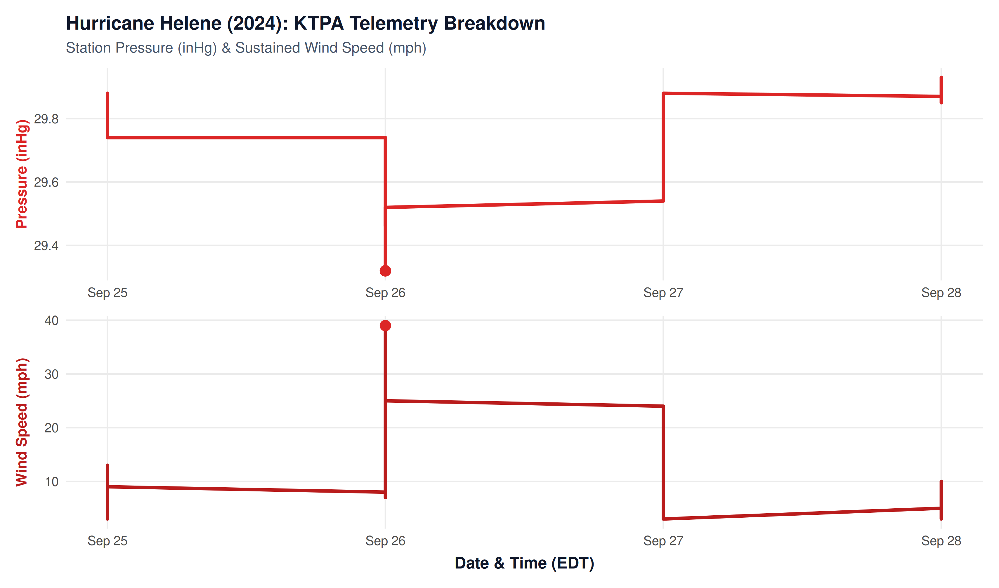
- Sharp Barometric Collapse: Despite the storm’s center being over 100 miles away, station pressure at KTPA plummeted to 29.32 inHg (992.9 hPa) on the evening of September 26.
- High Sustained Tropical Gales: Sustained winds reached 39 mph with gusts to 55 mph, knocking down electrical infrastructure throughout the coastal zone.
Hurricane Helene Landfall: Shape, Rotation & Wind Circulation
The interactive simulation below reconstructs Hurricane Helene at mainland Florida landfall near Perry / Big Bend (Cat 4, 140 mph). It visualizes the storm’s gargantuan 400-mile wind field, counter-clockwise rotation, and the resulting onshore southwesterly gales that drove a catastrophic, all-time record 6–7 ft storm surge into Tampa Bay.
REAL-TIME ROTATION SIMULATOR
Hurricane Helene: Animated Cloud Formation & Cyclonic Wind Field
Interactive 60fps canvas simulation: counter-clockwise cyclonic spin of convective cloud bands and wind field points with inward surface inflow deflection.
NoteExplore More Weather Crises
Return to the Natural Disasters Overview to view the full 10-year timeline, comparison tables, and summaries of all major storms.